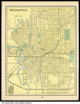
Street map of Indianapolis, Indiana, circa 1900
| Description: |
This street map goes as far north as 11th street, east to Randolph and Williams streets, as far south as Arlington and Sanford Streets, and as far west as the Stock Yards, Hadley, and River Avenues. |
|---|---|
| Origin: | 1900, circa |
| Source: |
http://indianaalbum.pastperfectonline.com/photo/25E8A7FD-FCFA-40D6-8EAB-126051425071 |
| Collection: |
Indiana Album |
| Rights: | http://rightsstatements.org/vocab/NoC-US/1.0/ |
| Geography: |
Indianapolis, Marion County, Indiana, United States |
| Subjects: |
Joan Hostetler Collection Maps Indianapolis (Ind.) Marion County (Ind.) |
Further information on this record can be found at its source.


