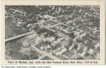
Aerial view of the Wabash, Markle, Indiana, circa 1975
| Description: |
Facing due north. Markle United Methodist Church is along the bank of the Wabash in the upper left. The bridge going over the Wabash is Highway 3, which changes into South Clark Road/North Clark Street as it goes into town.Front: View of Markle, Ind. with the Old Wabash River Bed, Hwy. I 69 at top.Back: Aerial View / Markle, Ind. 46770 / In 1970 about 789 people ived in this town in Huntington County. Hwy. 3, 116 and 224 go through the busy little town. Wayne Metal Products is the biggest employer in the community. |
|---|---|
| Origin: | 1975, circa |
| Source: |
http://indianaalbum.pastperfectonline.com/photo/73F57D6F-C746-4174-B6EA-313671113714 |
| Collection: |
Indiana Album |
| Rights: | http://rightsstatements.org/vocab/NoC-US/1.0/ |
| Geography: |
Markle, Huntington County, Indiana, United States 40.824633,-85.338873 |
| Subjects: |
Harley Sheets / Huntington County Collection Aerial photographs Aerial views Wabash River Markle (Ind.) Huntington County (Ind.) |
Further information on this record can be found at its source.


